The Lightning Imaging Sensor (LIS) was placed on the International Space Station in Feb 2017. LIS was mounted to the station as part of the U.S. Department of Defense (DoD) Space Test Program (STP)-H5 science and technology development payload. By placing LIS on the space station, which has a highly inclined orbit, a greater geographic range of measurements was obtained than previously measured by TRMM LIS. The ISS LIS provided total lightning measurements between +/- 48 degrees latitude which covered a geographic range that included nearly all global lightning. ISS LIS monitored total global lightning in both day and night and provided important cross-sensor calibration and validation with the Geostationary Lightning Mapper (GLM) and ground-based lightning networks.
ISS LIS supplied near real-time lightning data over data-sparse regions, such as oceans, to support operational weather forecasting and warning. ISS LIS standard science products are available at GHRC DAAC.
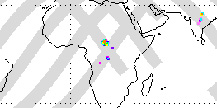
Please Note: LIS 12-hour data plots were created using near real-time data. A section of missing data due to communications drop-outs is visible in these plots extending from roughly 60 to 90 degrees E longitude.
Have you used our data? Register for updates
