Here's a great example of putting AMSR2 NRT data to practical use. To monitor tropical storm activity in the North Atlantic Basin we're using the MODIS instrument (on the NASA Aqua satellite) NRT data (from MODAPS) alongside the AMSR2 data (archived here at the GHRC DAAC). We're collecting ascending passes over the domain for a "daytime" image and descending passes for a "nighttime" image. (Both satellites have ascending pass equator crossing times of about 1:30 PM local time). The animation consists of twice per day images over the past 10 days – for the northern hemisphere tropical Atlantic Ocean basin. If tropical storms were present during the period, their paths are displayed.
The "base" map consists of landforms in shades of green and brown, with country/state borders - and the sea surface temperature (SST) in shades of red to light purple. SST is detected by AMSR2 (aboard the JAXA GCOM-W1 satellite). Sea waters near coastlines and in the Caribbean are shown as dark gray since SST retrievals are not dependable in shallow waters. Next, gray shades indicate significant clouds - detected by MODIS. Where the amount of liquid water in the atmosphere is significant, the Liquid Water Path (LWP) is depicted with a rainbow of colors - also generated from AMSR2 data. Since the MODIS and AMSR2 instruments are not in a "train" situation (following each other along nearly the same path) - there are occasionally patches of significant clouds (via MODIS) without accompanying LWP values (via AMSR2). There are also occasions where one or the other has a delay in processing, meaning the data are unavailable to the Hurricane Tracker software.
NASA’s Land, Atmosphere Near real-time Capability for Earth Observing Systems (LANCE) leverages existing satellite data processing systems in order to provide data and imagery available from select EOS instruments (currently AIRS, AMSR2, ISS LIS, MISR, MLS, MODIS, MOPITT, OMI, OMPS, and VIIRS) within 3 hours of satellite overpass. These data meet the timely needs of applications such as numerical weather and climate prediction, forecasting and monitoring natural hazards, agriculture, air quality and disaster relief.
The LANCE AMSR element at the AMSR SIPS generates Level-2B swath and incremental Level-3 daily products from the AMSR2 instrument on JAXA's GCOM-W1 satellite. The AMSR2 instrument was designed to detect water in all its state phases in the environment and monitor the water processes that exert a strong influence on climate and weather. NRT AMSR2 products are generally available 90 minutes after observation. AMSR-2 on JAXA's GCOM-W1 spacecraft, launched May 18, 2012.
GCOM-W1 AMSR2 Unified Level-2B Half-Orbit 25 km EASE-Grid Surface Soil Moisture product
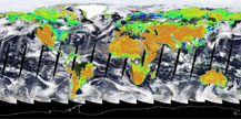
The LANCE ISS LIS element at the GHRC DAAC creates NRT lightning data products from the Lightning Imaging Sensor (LIS) on the International Space Station (ISS). NRT ISS LIS data are used for storm warnings, oceanic aviation safety and international Significant Meteorological (SIGMET) advisories, long-range lightning system validation, hurricane rapid intensification evaluations, and support of Fire Weather in the data sparse regions of the western United States. These data are available within two minutes of observation.
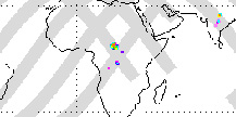
ISS LIS 12-hour Browse Image
Please Note: LIS 12-hour data plots are created using near real-time data. A section of missing data due to communications drop-outs is visible in these plots extending from roughly 60 to 90 degrees E longitude.
Have you used our data? Register for updates
